Case Studies: Fall 2012
This project was designed to give students an opportunity to conduct their own environmental histories. Each class member chose a location--either in Mount Pleasant or somewhere he/she knew well from his/her hometown or travel, and then explained how and why that place has changed over time. This is an exercise in historical, geographical, and environmental interpretation. As such, students were required to use both geospatial and historical data to support their analyses.
*This project was adapted from William Cronon's "Place Paper" assignment, which can be found here http://www.williamcronon.net/courses/460_syllabus_spring_2012.htm
*This project was adapted from William Cronon's "Place Paper" assignment, which can be found here http://www.williamcronon.net/courses/460_syllabus_spring_2012.htm
What's Been Buried, Doesn't Always Stay Buried
Case Study by Joel
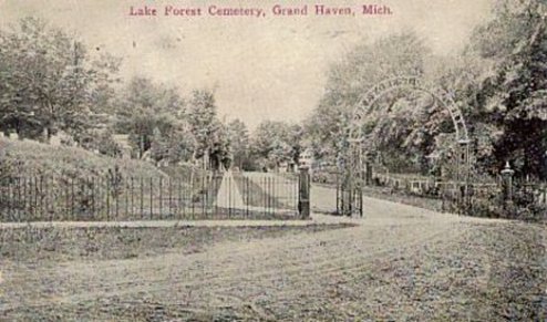
As a student of both German and Social Studies, I often end up making observations in a circular fashion during my education. For example, I chose a cemetery as the area for my case study, and this reminded me that cemetery in German is Friedhof. Fried is the stem of the word freidlich, meaning peaceful, and Hof is the German word for courtyard, so the literal translation of the word Friedhof is peaceful courtyard. This is a very apt description of the area, which encompasses a zone removed from the city center and the noise that accompanies it. The graveyard has green grass stretching from the road it is on to the forest that borders it, and the graveyard itself has tall old trees mixed with younger freshly planted trees dotting its fields of grass and stone. The historic Lake Forest Cemetery is well kept up and continues to create new gravesites within the area, but the older outskirts of the graveyard are noticeably being overtaken by nature with some older pathways and gravestones being destroyed by nature and erosion. This case study’s primary focus will be on the historical, geographical, and environmental impacts and issues of the Lake Forest Cemetery area and other cemeteries.
As a student of both German and Social Studies, I often end up making observations in a circular fashion during my education. For example, I chose a cemetery as the area for my case study, and this reminded me that cemetery in German is Friedhof. Fried is the stem of the word freidlich, meaning peaceful, and Hof is the German word for courtyard, so the literal translation of the word Friedhof is peaceful courtyard. This is a very apt description of the area, which encompasses a zone removed from the city center and the noise that accompanies it. The graveyard has green grass stretching from the road it is on to the forest that borders it, and the graveyard itself has tall old trees mixed with younger freshly planted trees dotting its fields of grass and stone. The historic Lake Forest Cemetery is well kept up and continues to create new gravesites within the area, but the older outskirts of the graveyard are noticeably being overtaken by nature with some older pathways and gravestones being destroyed by nature and erosion. This case study’s primary focus will be on the historical, geographical, and environmental impacts and issues of the Lake Forest Cemetery area and other cemeteries.
| whats_been_buried.pdf |
The Borden Building: Representing the Past and Present of Mount Pleasant
Case Study by Christine
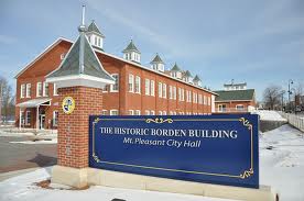
As I was walking up to my car one Tuesday afternoon, I was unpleasantly surprised to see a little green envelope under my windshield wiper. It was, of course, a parking ticket. I rolled my eyes and thought, “What a great way to start the semester.” I spent the whole day in an aggravated mood, and at work that evening I had to ask my client where the City Hall was so I could go there to pay my parking ticket. He laughed and pointed up the road and said, “That big building right there is the City Hall. I’m surprised you don’t know, considering you drive by it 5 days a week.” I was shocked. The beautiful brick building that I had been admiring for months was in fact the City Hall, also known as the Borden Building. In the next day leading up until when I actually paid my ticket, I found out that the City Offices have not always occupied the building, and that it was in fact a condensed milk factory back in the early 20th century. I was immediately fascinated. Upon entering the building, I was completely entranced by its elegance. I was shocked at how such a historic exterior could have such a modern interior. Ever since that moment, I have been interested in learning more about this building. After researching many aspects of the Borden Building, I have realized that it is central to Mt. Pleasant’s past and present in a number of ways.
As I was walking up to my car one Tuesday afternoon, I was unpleasantly surprised to see a little green envelope under my windshield wiper. It was, of course, a parking ticket. I rolled my eyes and thought, “What a great way to start the semester.” I spent the whole day in an aggravated mood, and at work that evening I had to ask my client where the City Hall was so I could go there to pay my parking ticket. He laughed and pointed up the road and said, “That big building right there is the City Hall. I’m surprised you don’t know, considering you drive by it 5 days a week.” I was shocked. The beautiful brick building that I had been admiring for months was in fact the City Hall, also known as the Borden Building. In the next day leading up until when I actually paid my ticket, I found out that the City Offices have not always occupied the building, and that it was in fact a condensed milk factory back in the early 20th century. I was immediately fascinated. Upon entering the building, I was completely entranced by its elegance. I was shocked at how such a historic exterior could have such a modern interior. Ever since that moment, I have been interested in learning more about this building. After researching many aspects of the Borden Building, I have realized that it is central to Mt. Pleasant’s past and present in a number of ways.
| borden_building.pdf |
Island Park: An Environmental Case StudyCase Study by Michele
Ecstatic children play on an intricate wooden play set. Drunken college students careen wildly over rushing rapids. Moody adolescents drop into concrete half-pipes. Men and women run after dogs across winding paths. A typical scene found in historic downtown Mt. Pleasant. For over a century, Island Park has been a gathering place for the residents of this growing city. Mt. Pleasant built itself on economic opportunity of various sources, beginning with timber, and expanding rapidly as new resources were discovered, utilized, and exploited. As the city changed, so did its use of land. Despite the rapid economic expansion of Mt. Pleasant, Island Park has remained a center for recreation and relaxing for residents. However, variations in its usage caused permanent change to the land itself. Human interaction with the landscape forever altered the physical presentation of this area, but not to the detriment of the natural system. Instead of destroying the environment with additions and customizations, the residents of Mt. Pleasant used the natural environment mostly to their advantage. Using local historic and current maps, images, and various historical references, my goal is to show that while humans certainly have changed the natural landscape, they have done so while keeping the environment largely intact. Their influences on the land have been made with their own advantages in mind, but they have managed to sustain the natural beauty and ecosystem of the area without too much alteration.
|
The Influence of Humans on Island Park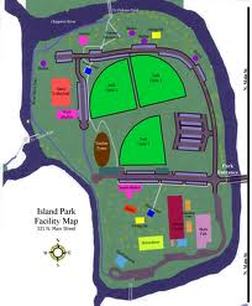
Case Study by Kyle
Island Park is a thirty-five acre city owned park located in Mount Pleasant, Michigan. The park lies almost directly in the center of Union Township of Isabella County and is completely surrounded by the Chippewa River. After looking at some maps of Mount Pleasant from as early as 1879, I have come to the realization that present day Island Park, which I have thoroughly observed first hand, looks drastically different than the property portrayed on the maps. Through the analysis of several secondary sources of the park’s history, multiple plat maps, some old news paper articles, a few old pictures, and information provided by Mt. Pleasant Parks and Recreation, I have come to the conclusion that humans have had a profound influence on the land. The relationship between man and nature is very interesting in the area of Island Park. The land has attracted many visitors for over a century and it is very evident that humans have altered and shaped the land into what it is today.
|
||||
Townline Creek Flooding State Wildlife Management Area
Case Study by Greg
Michigan is one of the most heavily forested states in the union with over fifty-five percent of it covered in trees held by the state, corporations and private individuals.1 The forested areas of the state continue to grow at a rate higher than any other state.2 These forests along with all other natural resources are owned by the residents of the state and held in trust to the Michigan Department of Natural Resources (DNR).3 The DNR has a hard job of maintaining some level of pristine wilderness for the residents of the state while still helping the state by using the land wisely for profit. Most of Michigan’s timber lands are conserved in an utilitarian way much like what Gifford Pinchot, the United States of Americas first Chief Forester, prescribed with is conservationist ideas. This utilitarian manner means that the woods are like a crop that is sustainably harvested in Michigan. This crop of timber is estimated to be worth nine-billion dollars a year and bring in the state close to two-hundred million dollars in tax revenue.4 Despite of this or maybe because of this the DNR has set aside areas that are not to be harvested and left for the people of the state to enjoy. These areas while managed, modified, open to hunting, trapping, and fishing are as close to John Muir’s goals of preservation as possible in American society. Managed areas like the Townline Creek Flooding State Wildlife Management Area are the best way to combine both of these men’s goals and have a multitude of advantages to the state and its residents. These advantages are both economical as well as environmental.
Michigan is one of the most heavily forested states in the union with over fifty-five percent of it covered in trees held by the state, corporations and private individuals.1 The forested areas of the state continue to grow at a rate higher than any other state.2 These forests along with all other natural resources are owned by the residents of the state and held in trust to the Michigan Department of Natural Resources (DNR).3 The DNR has a hard job of maintaining some level of pristine wilderness for the residents of the state while still helping the state by using the land wisely for profit. Most of Michigan’s timber lands are conserved in an utilitarian way much like what Gifford Pinchot, the United States of Americas first Chief Forester, prescribed with is conservationist ideas. This utilitarian manner means that the woods are like a crop that is sustainably harvested in Michigan. This crop of timber is estimated to be worth nine-billion dollars a year and bring in the state close to two-hundred million dollars in tax revenue.4 Despite of this or maybe because of this the DNR has set aside areas that are not to be harvested and left for the people of the state to enjoy. These areas while managed, modified, open to hunting, trapping, and fishing are as close to John Muir’s goals of preservation as possible in American society. Managed areas like the Townline Creek Flooding State Wildlife Management Area are the best way to combine both of these men’s goals and have a multitude of advantages to the state and its residents. These advantages are both economical as well as environmental.
| townline_creek.pdf |
Kelly/Shorts Stadium & the Surrounding Area
Case Study by Matt
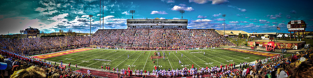
On Saturday’s in the fall, Central Michigan University students, fans, and alumni try to fill the 32,885 seats in Kelly/Shorts Stadium. The crowd roars the chant “Fire up Chips” and the team wears a “C” on its helmet for its nickname, the Chippewas – named after the Indian tribe that has roamed the same area for centuries. The parking lots that surround the stadium were once farmland, and before that dense forests. There are no more traces of the wolves, wolverines, beavers, wildcats, deer and muskrat’s used to explore a dense forest. The only animals in sight are a few birds looking to find some concessions left behind by fans.
On Saturday’s in the fall, Central Michigan University students, fans, and alumni try to fill the 32,885 seats in Kelly/Shorts Stadium. The crowd roars the chant “Fire up Chips” and the team wears a “C” on its helmet for its nickname, the Chippewas – named after the Indian tribe that has roamed the same area for centuries. The parking lots that surround the stadium were once farmland, and before that dense forests. There are no more traces of the wolves, wolverines, beavers, wildcats, deer and muskrat’s used to explore a dense forest. The only animals in sight are a few birds looking to find some concessions left behind by fans.
| kellyshortsstadium.pdf |
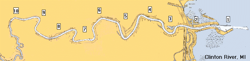
The Clinton River Spillway Canal: The Effects of Human/Environmental InteractionCase Study by Amanda
How long can the earth sustain human growth and development? Urbanization, industrialization, and population growth are three key ingredients to environmental degradation in the world today. Many citizens of the United States are aware that there is a growing threat to the environment, but it is hard to admit that we, as the human race are the problem. It is obvious that urban and city centers have altered what natural landscape had existed before; however, is there a change of heart if the problem lay in one’s own backyard? The Clinton River Watershed is an area of lower southeastern Michigan that is under the attack of human influences and population growth. As a citizen of that watershed, I am a contributing factor to this ongoing problem of landscape alteration and unnatural change. A major area of concern in this particular watershed is the area of The Clinton River Spillway, which runs from Mt. Clemens, Michigan to Lake St. Clair. This man made spillway was created with the intentions to control flooding in the watershed; however, the planning behind this project failed to recognize the environmental harm that it would cause in the future, and now our generation and the environment are paying the ultimate price!
|
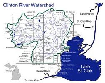
The Clinton River: A Case StudyCase Study by Andrew
The time is the 1970’s and the place is Mt. Clemens, Michigan. On a summer afternoon, one can see a group of children at play. In their backyard, a slide leads to the Clinton River, flowing with a bright, reflective surface. Today, the slide still sits in the backyard, but the scene in the river is much different. The glistening stream of the Clinton was replaced with sewage and pollution. The clear waters are now a dull, murky brown. A passerby would look at the slide in disbelief that anyone in their right mind would want to swim in such infested water. The Clinton has had a terrible recent history, from a scenic piece of nature to a garbage dump that is a shell of its former self. The Clinton River’s downfall can be attributed to the increase in industrialization in Macomb and Oakland counties and the pollutants that follow, but efforts over the past twenty plus years have made much progress in cleaning the Clinton River.
|
||||
Schoolhouse Study: Tracking Environmental Change in Kingsley, MI
Case Study by Emily
Kingsley, Michigan is a small town that is located fifteen miles south of Traverse City in beautiful northern Michigan. Kingsley was founded in the late 19th century and thrived off the lumber boom. Then, as the lumber boom subsided agricultural became the main economic base. Finally, beginning in the 1960s and 1970s road and transportation improvements made Traverse City more accessible, and Traverse City became the main employer of Kingsley residents. Like so many small towns, the schoolhouse was an integral part of the community. As the town grew and changed, so did the schoolhouse and the land surrounding it. By studying the school house and the land surrounding it, one can track the growth of this small town. The biggest factor influencing the development of the school and this particular plot of land is the economic opportunities provided by the surrounding areas.
Kingsley, Michigan is a small town that is located fifteen miles south of Traverse City in beautiful northern Michigan. Kingsley was founded in the late 19th century and thrived off the lumber boom. Then, as the lumber boom subsided agricultural became the main economic base. Finally, beginning in the 1960s and 1970s road and transportation improvements made Traverse City more accessible, and Traverse City became the main employer of Kingsley residents. Like so many small towns, the schoolhouse was an integral part of the community. As the town grew and changed, so did the schoolhouse and the land surrounding it. By studying the school house and the land surrounding it, one can track the growth of this small town. The biggest factor influencing the development of the school and this particular plot of land is the economic opportunities provided by the surrounding areas.
| kingsley.pdf |


Oakland Hills Country Club & Environmental Change
Case Study by Amy
“The Lord intended this land to be a golf course,” said architect Donald Ross when he first saw the land that would soon be known as Oakland Hills Country Club. From a rolling pasture to a historical and world renowned golf course, Oakland Hills Country Club is almost 100 years old with much history in the land, the club, and its members. Donald Ross was the architect who designed the club which is still the same basic structure today. Located in Bloomfield Township, Oakland Hills is made up of two golf courses; north and south, a club house, and Olympic sized swimming pool. This is a private country club that has over five hundred members (not including their spouses and children). Many different golf tournaments have been held at this beautiful course such as, six United States Open championships, three PGA’s, two United States Senior Opens, one United States Women’s Amateur, a Western Open, a Ryder Cup, and the United States Amateur. There is no arguing when saying that this club is prestigious and historic. The question sought out for this case study was; what was there before Oakland Hills, the land that the lord deemed worthy of a golf course, and how has it changed over the years in order to keep up with the standards that its members have for their club?
“The Lord intended this land to be a golf course,” said architect Donald Ross when he first saw the land that would soon be known as Oakland Hills Country Club. From a rolling pasture to a historical and world renowned golf course, Oakland Hills Country Club is almost 100 years old with much history in the land, the club, and its members. Donald Ross was the architect who designed the club which is still the same basic structure today. Located in Bloomfield Township, Oakland Hills is made up of two golf courses; north and south, a club house, and Olympic sized swimming pool. This is a private country club that has over five hundred members (not including their spouses and children). Many different golf tournaments have been held at this beautiful course such as, six United States Open championships, three PGA’s, two United States Senior Opens, one United States Women’s Amateur, a Western Open, a Ryder Cup, and the United States Amateur. There is no arguing when saying that this club is prestigious and historic. The question sought out for this case study was; what was there before Oakland Hills, the land that the lord deemed worthy of a golf course, and how has it changed over the years in order to keep up with the standards that its members have for their club?
| oakland_cc_case_study.pdf |
Big Changes, Yet Still a Small Town
Case Study by Mary
Nestled a mere forty five miles west of Detroit stands my hometown of Brighton, Michigan. Growing up there for the past twenty years I have come to adore this place that I call home. Through my upbringing my passion has always revolved around the downtown area that is often called “Main Street.” Main Street never ceases to amaze me with is booming business and ever growing business opportunities. Through my case study I was able to see that since the start of the downtown district at the turn of the 19th century to today there have been many factors that have aided to the growth of this area, yet it still maintains the small town feel. Through a rise in suburban growth, technological advances, preservation of downtown, Main Street has been shaped into a major attraction for people today.
Nestled a mere forty five miles west of Detroit stands my hometown of Brighton, Michigan. Growing up there for the past twenty years I have come to adore this place that I call home. Through my upbringing my passion has always revolved around the downtown area that is often called “Main Street.” Main Street never ceases to amaze me with is booming business and ever growing business opportunities. Through my case study I was able to see that since the start of the downtown district at the turn of the 19th century to today there have been many factors that have aided to the growth of this area, yet it still maintains the small town feel. Through a rise in suburban growth, technological advances, preservation of downtown, Main Street has been shaped into a major attraction for people today.
| brighton.pdf |
Velsicol Superfund Site
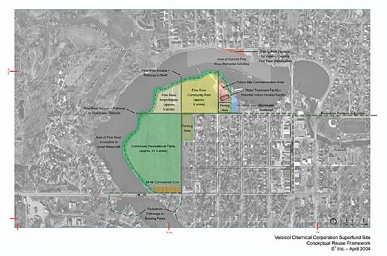
Case Study by Kiley
Approximately 10,000 years ago, when the last great continental glacier melted and retreated across what is now known as Michigan, all of the rivers and lakes we know today were created. The Pine River, located almost directly in the middle of Michigan, was formed the same way: “The Pine River sub-basin (or watershed) is 427 square miles in size along its 51-mile length” (1). The Pine River begins in Mecosta County and runs alongside the Montcalm County border before going directly through Gratiot County. The Pine flows through Alma and St. Louis, Michigan before meeting up with the Chippewa River and dumping off into the Tittabawassee River. From there the Tittabawassee flows directly into Lake Huron. The Pine River has been an important river since settlers came to these parts hundreds of years ago. Loggers in the late 1800’s used the Pine River extensively for logging. There are many small villages along the Pine River and they can be traced back to when loggers settled those areas. The Pine River used to known for logging and clear waters. Today it is known as one of the dirtiest and most contaminated cites one can find. The Pine River is home to one of the most expensive Superfund sites in US history.
Approximately 10,000 years ago, when the last great continental glacier melted and retreated across what is now known as Michigan, all of the rivers and lakes we know today were created. The Pine River, located almost directly in the middle of Michigan, was formed the same way: “The Pine River sub-basin (or watershed) is 427 square miles in size along its 51-mile length” (1). The Pine River begins in Mecosta County and runs alongside the Montcalm County border before going directly through Gratiot County. The Pine flows through Alma and St. Louis, Michigan before meeting up with the Chippewa River and dumping off into the Tittabawassee River. From there the Tittabawassee flows directly into Lake Huron. The Pine River has been an important river since settlers came to these parts hundreds of years ago. Loggers in the late 1800’s used the Pine River extensively for logging. There are many small villages along the Pine River and they can be traced back to when loggers settled those areas. The Pine River used to known for logging and clear waters. Today it is known as one of the dirtiest and most contaminated cites one can find. The Pine River is home to one of the most expensive Superfund sites in US history.
| velsicol.pdf |
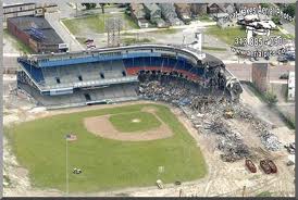 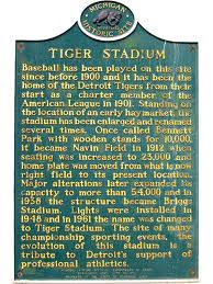 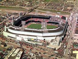 The Environmental History of Tiger StadiumCase Study by Patrick
Baseball had been played at the corner of Michigan and Trumbull in Detroit for 104 years, from 1896-1999. Over the years the stadium has gone through a number of changes, much like the city of Detroit. Before Detroit was founded in 1701, the land surrounding the site of Tiger Stadium was a large primeval forest filled with ash, birch, hickory, oak, and cedar and pine trees. Native Americans roamed these lands and hunted elk, turkey, moose, bear, and deer. They also picked strawberries, cranberries and raspberries.
|
A Look at Ann ArborCase Study by Aaron J.
Ann Arbor is just one of many cities within Michigan, but it has a unique character of its own. Part of this is due to having the University of Michigan harbored within the city, but that is just one reason Ann Arbor stands out. Its character is still wrapped up in the small town feel it maintained even after becoming a city. The many buildings within the city are just one example of what sets Ann Arbor apart from the other city in Michigan. The structures standing within the two city blocks contained by the streets of East Liberty in the north, South State in the east, East Williams to the south, and Thompson street to the north with Maynard running north to south connecting to Williams and Liberty can serve as an example to what makes Ann Arbor what it is today. This area also serves to show how the city has changed. Before we can examine the sample location, a general history of Ann Arbor may serve as a guide to how this city has evolved over time.
|
||||
Harbor Beach, Michigan
Case Study by Sean
When it came to thinking of the most logical place to do my case study, it was obvious to choose my hometown of Harbor Beach, MI. Harbor Beach has been my home and will always be my true home. To others it may seem like a small rundown town in the middle of “Redneck” county, USA, but there is more than just fields of corn, sugar beets, hay, etc. There is a 2,000-person community where everyone knows everyone, where major crimes such as murder rarely, if ever, occur. With the numerous pine, birch, oak, and apple trees, the woods give home to many wild life and the beachfront gives a beautiful sunrise where the rays of the sun simmer on Lake Huron. At night during Christmas season you witness the light of not only the colorful decorations on the houses, but also the light of the moon reflecting off the powdery snow on the ground. I will go on to explain the history of various places in Harbor Beach where I have significant ties with my life, after which I will discuss what environmental issues surround Harbor Beach today.
When it came to thinking of the most logical place to do my case study, it was obvious to choose my hometown of Harbor Beach, MI. Harbor Beach has been my home and will always be my true home. To others it may seem like a small rundown town in the middle of “Redneck” county, USA, but there is more than just fields of corn, sugar beets, hay, etc. There is a 2,000-person community where everyone knows everyone, where major crimes such as murder rarely, if ever, occur. With the numerous pine, birch, oak, and apple trees, the woods give home to many wild life and the beachfront gives a beautiful sunrise where the rays of the sun simmer on Lake Huron. At night during Christmas season you witness the light of not only the colorful decorations on the houses, but also the light of the moon reflecting off the powdery snow on the ground. I will go on to explain the history of various places in Harbor Beach where I have significant ties with my life, after which I will discuss what environmental issues surround Harbor Beach today.
| harbor_beach.pdf |
John & Addie, Their Descendants, & "The Forty"
Case Study by Aaron C.
The significance of the relationship between humans and their impact on the environment, and the environment and its impact on humans can be seen on many different levels: global, state, local, communal, and even individual. This can be demonstrated in the changes with humans, the human society, culture, and through the environment. Within the United States of America, in the small section of Winn, Michigan, the reciprocal relationship between humans and the environment can be seen through John and Addie Riggle. They’re descendants using the natural resources of the environment for their own self preservation and sustainability and the effects of this have had lasting impacts on the environment that can still be seen.
The significance of the relationship between humans and their impact on the environment, and the environment and its impact on humans can be seen on many different levels: global, state, local, communal, and even individual. This can be demonstrated in the changes with humans, the human society, culture, and through the environment. Within the United States of America, in the small section of Winn, Michigan, the reciprocal relationship between humans and the environment can be seen through John and Addie Riggle. They’re descendants using the natural resources of the environment for their own self preservation and sustainability and the effects of this have had lasting impacts on the environment that can still be seen.
| the_forty.pdf |
